



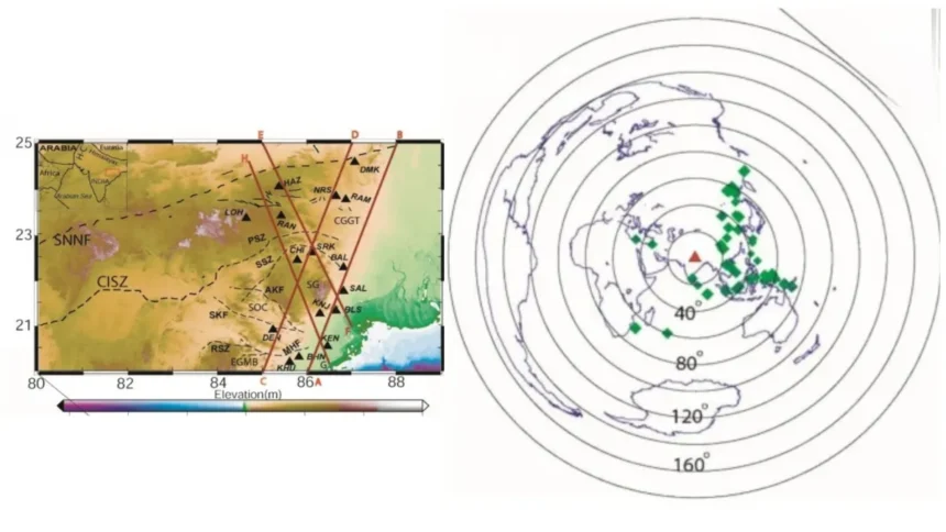
A new study has provided the first detailed look at the Earth’s interior directly beneath the Eastern Indian craton, an ancient fragment of the Earth’s crust that has remained stable for over three billion years. Using a network of 16 broadband seismic stations spread across the states of Odisha and Jharkhand, Dr Prantik Mandal from the CSIR-National Geophysical Research Institute (CSIR-NGRI) in Hyderabad has mapped a mysterious region known as the Mantle Transition Zone (MTZ). The findings reveal that this deep-earth layer is roughly 235 kilometres thick and contains evidence of ancient water and recycled ocean floors, offering a rare glimpse into the inner workings of our planet.
The Mantle Transition Zone acts as a critical gateway between the Earth’s upper and lower mantle, sitting roughly between 410 and 660 kilometres below our feet. To see this deep, Prantik used a technique called P-receiver function imaging, which functions much like a medical ultrasound. When earthquakes occur elsewhere in the world, the seismic waves they produce travel through the Earth’s interior. As these waves hit major boundaries, such as the top or bottom of the transition zone, they change speed and direction. By recording 666 of these specific wave conversions, Prantik was able to calculate the depth and composition of the structures beneath the Eastern India craton with unprecedented precision.
At depths below the upper mantle, immense pressure and temperature induce changes in common elements and compounds. At the 410-kilometre mark, the mineral olivine transforms into a denser form called wadsleyite; at 660 kilometres, it changes again into bridgmanite. The speed of seismic waves changes abruptly at these points, creating discontinuities. The study found that while the thickness of the MTZ beneath Eastern India is close to the global average, significant low-velocity layers are sitting just above these boundaries. These layers act like speed bumps, slowing seismic waves, which strongly suggests the presence of either partially melted rock or water-saturated minerals.
Geologically, these findings are a time capsule. The research suggests that the transition zone beneath India holds between 0.1 and 0.3 per cent water by weight. While that may sound like a small amount, at these depths and scales, it represents a massive reservoir of volatiles. This moisture likely infiltrated the deep earth during the assembly of the supercontinent Gondwana roughly 550 million years ago, or more recently during the ongoing collision between India and Asia that created the Himalayas. Furthermore, the evidence of stagnant material at the bottom of the zone suggests that remnants of ancient ocean floors, subducted millions of years ago, are currently piling up beneath the Indian plate.
By deploying a denser network of seismographs specifically across the Singhbhum-Odisha region, this study provides the first detailed constraints on the Eastern Indian craton’s deep structure. It moves the scientific conversation from broad guesses to specific measurements of how the temperature and chemistry of the mantle vary across different parts of the country.
However, the study also highlights the inherent difficulties of seeing through hundreds of kilometres of solid rock. Prantik notes that while the low-velocity layers are a compelling explanation for the data, they are not yet a certainty. The dips in seismic speed could also be explained by the alignment of minerals in the rock, a phenomenon called anisotropy, or potentially as artefacts created during the complex mathematical processing of the seismic signals. To confirm if this is truly a deep-earth water tank, scientists will need to follow up with other methods, such as magnetotellurics, which measure the Earth’s electrical conductivity.
The research helps us understand the long-term stability and evolution of the land we live on. Cratons like the one in Eastern India are the anchors of continents. Understanding their deep-rooted structure helps geologists predict how the continent will react to tectonic stresses and where seismic activity might occur. Furthermore, studying the Earth’s deep-water cycle is essential for understanding the long-term climate and habitability of our planet, as the movement of water between the surface and the deep mantle regulates everything from volcanic activity to atmospheric formation. By mapping the deep foundations of the land, scientists are helping us understand the ancient forces that built the ground beneath our feet and the processes that continue to sustain it.
Disclaimer: This content has not been generated, created or edited by Finance SC. Publisher:
Source link
Source link